Saturday, December 29, 2012

Snow Still To Fal In Pennsylvania, How Much!


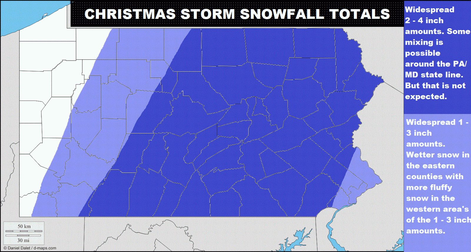
As we look at the current radar, there are very intense bands of snow throughout the northern part of Pennsylvainia, keep in mind, the brunt of this storm is still down in the southeast. There are also bands of snow moving northeast from central Maryland and northern Virginia. That should start to impact counties like Franklin, Adams, Cumberland, York, Dauphin, Lebanon, and Lancaster. That band should produce about 1-3 inches in those cunties with locally higher amounts on the ridgetops of those area's like south mountain, where it is likely colder and the ratio is better. There is also a band of snow moving into are southeastern counties like Piladelphia and Delaware, as well as Mongomery, and Bucks. The ratio's are terrible over there because the temperatures are very warm there, so those area's in southeastern Pennsylvania may only get a half an inch of possibly an inch in Bucks county. The snow is falling in central and northern Pennsylvania,a dn we think the snow will continue to fall there for 3 or 4 hours more. After the snow ends, i expect the Lake Effect Snow Machine to kick in and give area's like Bradford another 2 - 4 inches after the snow ends. I think the snow could be over in area's like Greene county Pennsylvania because  there are no excisting bands moving itnto southwestern Pennsylvania. This is pretty much what I expect to happen with this storm. I will have updates if anything changes. After this storm, it looks like we will have a dy and chilly period lasting about a week bacause af a high that will setup over the northeastern part of ths United States.

Thursday, December 27, 2012

More Snow Likely This Weekend


As you can see, we are expecting another snow event for this weekend, it will not be as significant as the previous snowstorm, but this storm will still give Pennsylvania some plowable snow in area's. This storm will ride up the coast and this storm would dump and dump snow on our region, but the storm is expected to be ferther off the coast then the last storm. We will have the cold air throughout the state, unlike the last storm. This storm will arive late Friday night or Saturday morning and bring heavy snow to central and eastern Pennsylvania. This storm will continue to produce snow through the morning hours. Once we get into the afternoon, this storm will still be impacting our area will heavy snow at times. After that, this storm will begin to lift out of the region southwest to northeast.This storm should leave a snowy seen of about 2 - 4 inches in the blue area and 4 - 6 inches in the purple areas.

Tuesday, December 25, 2012

New 12z Euro For 26th - 29th Storm


Signifficant Snow's Still Expected To Hit Pennsylvania With The 26th - 28th Storm

So, as you can see, we will be dealing with a pretty major snowstorm for most of our state. I know a lot of people like me will be traveling during this snowstorm, but want to find out when to get somewhwre without being snowed in. Here's the track of this storm. We will have a low forming in the southern plains, giving parts of OK and TX up to a foot of snow. That storm will move east and grab some moisture from the gulf, creating a severe weather outbreak for parts of the gulf ocast state's Christmas day. This storm will strengthen and then move northeast through central Tennessee and continue to grab moisture off the gulf, it will then move northeast still into western West Virginia, it will now be pretty strong, but now as soon as you know it, a secondary low will form in southeastern Virginia as grab moisture off the Atlantic, then the energy from the primary low in West Virginia will transfer to this secondary low, which will no be very strong. From that point, the secondary low, now primary low, will move north-north east over the Del - Mar - Va and extreme southeastern Pennsylvania, around Philadelphia, some warm air will get into extreme southeastern Pennsylvania from where the storm center is, explaining the all rain area in extreme southeastern Pennsylvania. This storm will destroy everywhere else in Pennsylvania with heavy snow for a long period of time.
As you can see, anywhere in area's west and north of Lancaster should see at least 9 inches. We expect ths storm to be a one to remember because this storm alone will likely give some area's in area's like York and Harrisburg more snow than they got the whole last winter!

Sunday, December 23, 2012

New 00z Euro Still Shows Cold Air With Significant Snow's For The 26-28 Storm

As you can see, we should have a major snowstorm on our hands in a few days. This storm should affect Pennsylvania vey hardly. Here is the track of this storm, it will develop in Texasand really grab lots of moisture from the gulf. It is likely the to move through northern Alabama and central or eastern Tenesssee. Then from there, it will move into western North Carolina and West Virginia, as well as western area's of Virginia. You might be thinking, so far, dosen't this mean rain for our area. Well, in extreme southwestern Virginia, the primary low will feed moisture to a developing secondary low in southeastern Virginia. After that, the primary low ahould weaken signifficanty but still be excisting. By this time, almost all of the energy from the primary low has joined forces with the developed secondary low. This secondary low will then move NNE, over the central Del-Mar-Va. This storm will now move in a northeasterly motion and move just west of Long Island, and likely right over the capes of southeastern Massachusetts. So, with this storm moving to the south and east of our area, that dumps significan snows for us. So in this model, you see these 18-24 inch amounts and probably had a heart attack, well in area's like Bradford or in the northwesten part of Pennsylvania, they will already have a foot of snow before this storm starts from lake effect or the mini Christmas storm. So really, when you see thr 18-24 inches area, its really only about 8-12 inches. But here's where we talk about real snow. You see the area of 12-18 inches in the Pocono mountains, most of that however is fresh powder. Then you see an area of 9-12 inches extending from around just north of Pittsburgh to area's like York, then going to area's like East Stroudsburg, I actually think this area could be in the 12-18 inches range because I think the temperatures will likely be 1 or 2 degrees colder than what the this 00z euro model says. This area will still have temperatures cold enough for the whole storm to support snow, and I think if we get 1 or 2 degrees colder than the new 00z euro says, we would have a slightly better ratio. Then you see area's in 6-9 inches from Pittsburgh to Lancaster, to Allentown, once again, in these area's I think could have a slightly better ratio then stated by this model because this ratio is based off or a temperature of 32 degrees. We will have temperatures for highs in the lower 30's for the area's in 9-12 inches and possibly northern area's of the 6-9 inches range. The overnight lows will likely be in the low - mid 20's, in the 9-12 and 12-18 inch ranges, supporting a 16 to 1 ratio, not a 10 to 1 ratio like this model is based off of. So now we get into the 3-6 area where this model once again has ever so slightly warmer temperatures.I think this area will see around 6-9 inches of snow, pretty much in every area, I think should be moved up one more stage except the 12-18 inches range. Then you have of 1-3 inches in extreme southeastern Pennsylvania, around Philadelphia. I think this area will see more like 3-5 inches, but this is the area that I am slightly more concerned abut because it will be so close to the center of the storm. This is the area that will need to pay close attention to their radar with this storm to see where that rain-mix-snow line is. But, this area will by far have the wetest snow out of everybody in the state of Pennsylvania.
Above you have the temperatues when the storm is really impacting the Pennsylvania area significantly. This is a reason why the previous snowfall model had lesser amounts in the far southeast. So in this model you have temperatues in the low-mid 20's in the northwestern part of Pennsylvania, at that point, you have about a 18-1 ratio. Then you have widespread area's of temperatures in the upper 20's, which is about a 14-1 ratio. But, like I stated several times, I expect temperatues to actually be 1-3 degrees colder than this model shows, putting area's anwhere north or east of the 540 line, temperatures in the upper 20's, giving them a better ratio. After that, you have an area of temperatures in the low-mid 30's around southern Berks county, souhern Mongomery county, Philadelphia county, Delaware county, and extreme south Lancaster county. So overall, I expect tempertures for almost every area in Pennsylvania to be below freezing for this whole storm, except area's in the far southeast. Now, just to say, the new euro today shifted this storm farther south and east, yesterday at this time, we were looking at an rain storm, be believed the models yestarday had convective feedback issues. The model changed, but I am not going to pay attention to the gfs models because they talke a long time to get away from issues after they just had them, and still do.
Here is my snowfall totals map for this storm. I will have more details on this storm tomorrow, so stay tuned right here. I have a 65% confidence of this storm. I will have more updates on all of the storms set to affect Pennsylvania and trust me, there are a lot, so I will be updating a lot, but for now, good bye!

Saturday, December 22, 2012

Christmas Storm Snowfall Totals

So, here is a summary of this Christmas eve - Christmas day storm. This storm will come in from the south and it will go up the coast. This will spread a good healthy area of snow throughout area's in the northeast, like Pennsylvania. This storm could start out as a mix around the extreme southern counties of Pennsylvania, or the southeastern counties. This storm will overspread the region wit snow late Christmas eve, giving snow to the majority of the area. Like I said, there could be a few area's of sleet or even rain in counties like Philadelphia and Bucks. The snow will continue to fall through the night and could be heavy at times. The storm should be wrapped up at about early mid-day Christmas, (Tuesday). This storm should put down amounts of 2 - 4 inches in the dark blue area's and possibly an area up to 5 or 6 inches. Models are leaning towards possibly heavier amounts possible in counties like Franklin, Adams, York, and Lancaster. Right after this storm, there will be a much more significant storm on around Wednesday - Friday. Even though the euro went warmer today, I think it went through convective feedback issues. This storm is likely to be all snow for everyone and most models are saying a foot plus in central and eastern Pennsylvania. I will have updates on these two storms constantly. Stay safe and be sure to check back for the latest forecasts and outlooks!